Is Max Eberle as big as a goof as I now think?

I never said it was. But I'm saying that I don't believe that the stated curvature is accurate.

He's the Lake Michigan link. It is a more simple example for you to wrap your heads around.
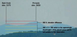
https://www.youtube.com/watch?v=o37t6iBS_q4

You have posted this link about Lake Michigan several times, I still do not understand what your point is. I can assure you from personal experience that when out on Lake Michigan in a boat that you can see short buildings starting to disappear at less than 10 miles out when shore is still clearly visible. Milwaukee's port is generally much more clear than Chicago's port. If you are trying to prove the curvature of the earth then your video link is very helpful.
 
You aren't being attacked. You're being discredited.
Since I didn't produce either video, that is impossible. I use the words "sea level" to mean close to the ground and you guys interpret that to mean that the guy that produced the vid missed 10 feet.
 
You have posted this link about Lake Michigan several times, I still do not understand what your point is. I can assure you from personal experience that when out on Lake Michigan in a boat that you can see short buildings starting to disappear at less than 10 miles out when shore is still clearly visible. Milwaukee's port is generally much more clear than Chicago's port. If you are trying to prove the curvature of the earth then your video link is very helpful.

If you watched the vid, then you will see that 220 meters or ~722 feet of the buildings from 40 miles out that can indeed be seen, should actually be below the horizon due to the curvature of the earth.

This really isn't that complicated.
 
Well, since Lost_His_Grip seems to have neither the time nor the ability to make a drawing, I went ahead and did one. Here are two 5400-foot peaks about 36 miles apart. The horizontal scale is compressed so that the curvature of what would be a plain at sea level is visible and amounts to a 250-foot bulge in the middle.

I think you can see one peak from the other.

Maybe someone would like to include the intervening features if they're important.

View attachment 440872
Except that the attached is the relevant pictorial representation showing that a drop of 770 feet means that the peak should be below the bottom yellow line from his exact view from his elevation.
 

Attachments

  • Flat Earth... A Mountain of Evidence - YouTube - Mozilla Firefox 2016-11-17 14.37.48.jpg
    Flat Earth... A Mountain of Evidence - YouTube - Mozilla Firefox 2016-11-17 14.37.48.jpg
    135.5 KB · Views: 186
There would be no arguments at all about the shape of planet earth if someone for example were to go into outer space, like a mission to the moon would be cool. Wonder why no country has ever taken that on. The country that accomplished it could not lie about its achievements if it had an open space policy, the media and even other countries would have access to what the aforementioned country had learned. It would be especially difficult for the successful country to lie if they were in a space race with another country for example. Especially if there was much tension over weapons and military strength between the succeeding and not so much succeeding country. Oh how I yearn for a fascinating story like this.
On the other hand we could just agree with all the conspiracy theory nut jobs and call the Earth flat but I wonder what shape Earth would take on if we agreed? I have a feeling that the real shape of Earth really does not matter to them, they just want to come up with more conspiracy theories so they can argue more.
 
You guys are hilarious. Attack the person bringing you the information, instead of accurately reviewing the information. I used the word "sea level", but the guy doing the vid never said that and I am well aware that lake level is not equal to sea level.

Let's just say I've had a few advanced math courses (calculus and differential equations), I've had various physics courses (including thermodynamics and quantum mechanics), I have a degree in Chemistry and I've worked in R&D and various other technical and quality areas for over 25 years. But of course, none of that matters or is the point. The ad hominem attacks are quite immature and who "I" am is irrelevant.

Next you will point out a spelling error and say that I'm illiterate. All quite juvenile.

Well you are defending that information.

Quite poorly in fact.
 
I am well aware of that. I used "sea level" in a generic sense. If you think 30 feet had a difference in the conclusions, you are deluded. Like I said, you are using minor technicalities, now in wording to try to throw the baby out with the bath water.

Here is a vid where that guy explains in more detail the calculations, if you're interested.
https://www.youtube.com/watch?v=vPWLqlGLVag

When I said "sea level", I meant from the ground. I believe that this guy took into account the height above sea level in his calculations, but I will need to watch the vid again.

If you think that video has any mathematical validity, you have no concept of three dimensional geometry. Here's a hint. You are a fixed point on a sphere. No matter which direction you're looking in, you're on an "equator". There's no "smaller" circumference depending on where you're looking. You are always on an equator.
 
here go for a ride and see for yourself, sheesh 2016 and this is actually being debated :rolleyes:
http://www.cnn.com/videos/us/2016/03/07/future-of-adventure-space-tourism-orig-ff.cnn
Oh....that's an easy one. Civilian rocket that they were trying to send into space got about 73 miles and hit something and could go no further. Some speculate that this is the firmament described in the Bible, and some believe that it is a type of liquid. :thumbup:
https://www.youtube.com/watch?v=IAcp3BFBYw4

Oh, and that balloon vid was filmed with a fish-eye lense. Everything looks curved through those things.
 
Last edited:
If you think that video has any mathematical validity, you have no concept of three dimensional geometry. Here's a hint. You are a fixed point on a sphere. No matter which direction you're looking in, you're on an "equator". There's no "smaller" circumference depending on where you're looking. You are always on an equator.
I just forwarded the vid of the guys explanation. I did not say that I've studied that particular vid and agree with it's contents.
 
Last edited:
Well you are defending that information.

Quite poorly in fact.
Right. And you would know. Everyone is picking at irrelevant points. The calculation for the drop in 34 miles is: 8 inches x 34 miles x 34 miles = 9248 inches / 12 = 770 feet.

So the peak of the mountain should have dropped 770 feet and would be just under the terrain in front of the guys view and thus shouldn't be seen.

That's all there is to it.

No. The bottom 770ft of the mountain would be concealed by the curvature of the earth. Which leaves 4630ft left for your viewing pleasure.
 
No. The bottom 770ft of the mountain would be concealed by the curvature of the earth. Which leaves 4630ft left for your viewing pleasure.
Same thing. The base of the mountain and every point to the top drop the same 770 feet to leave only the top part visible. But again, you're splitting hairs.

But of course, in this case -- the "top" is still above the horizon, but below the terrain from his point of view.
 
... would be just under the terrain in front of the guys view and th ...
That depends on the exact profile of the terrain between the two peaks and the camera angle chosen. You have failed to provide the requested terrain contour, so nothing can be deduced from the FE idiot's video.

It is unfortunate that such a video can take in so many sloppy thinkers.
 
Same thing. The base of the mountain and every point to the top drop the same 770 feet to leave only the top part visible. But again, you're splitting hairs.

Lol. "Same thing"?

You really need to let me know where you did R&D. I'd like to know which products to avoid.
 
That depends on the exact profile of the terrain between the two peaks and the camera angle chosen. You have failed to provide the requested terrain contour, so nothing can be deduced from the FE idiot's video.

It is unfortunate that such a video can take in so many sloppy thinkers.

Did you check out the "different circumference" video he posted, as well?
 
Lol. "Same thing"?

You really need to let me know where you did R&D. I'd like to know which products to avoid.
You are so obtuse I can't even explain black and white to you. The WHOLE mountain sinks 770 feet leaving the top part exposed. But in this case the top should even be under the terrain. You are picking at ridiculous points and subtle wording that you think somehow proofs that the facts are not the facts. Please tell me that you're not married.
 
Back
Top